Dayton Street Transit Center
Posted: January 23, 2013 Filed under: Transit 2 CommentsWhen Ben Franklin Transit first started operations in 1982, they had no transit centers. Instead, buses connected at a designated street block/intersection or private parking lot. In Pasco, buses stopped on 4th Ave between Lewis St and Columbia St, next to the modern location of the Pasco Farmer’s Market. In Richland, the transfer point was at the corner of Knight St and Jadwin Ave, next to the Federal Building. (If you go there today, you can still see where the bus pullouts were.) In West Richland, buses stopped on Van Giesen St, next to West Richland City Hall. In Kennewick, there were 3 different transfer points. On the west end of the city, there was a transfer point in the parking lot of Columbia Center Mall (first on the east end, later moved to the west end where it remained until Three Rivers TC was built.) In the central part of the city, buses connected on Morain St just north of Clearwater Ave near the site of the old Sanders Field until Huntington TC, BFT’s first transit center, was opened in 1986. Lastly, there is east Kennewick, and that’s what I’m going to be focusing on in this post.

Dayton Street Transfer Point (July 2011)
In the beginning, east Kennewick had a transfer point at the corner of 6th Ave and Auburn St, next to the Benton PUD building (more recently the location of the Kennewick School District offices, and now vacant). Sometime in the mid-1980’s, a curbside transfer point was built on the 900-block of South Dayton St next to Columbia Industries. Apart from a widened sidewalk and some concrete benches, it was a very minimalist facility. (It does still get used on occasion presently when the Cavalcade of Bands or the Benton Franklin Fair Parade closes streets in the downtown area.) Some years later, the transfer point was moved yet again to the current location on the 200-block of South Dayton St next to Keewaydin Park. Like the previous transfer point at Columbia Industries, the sidewalk was widened to accommodate the extra foot traffic. A rest station (operator bathrooms and maintenance closet) was also constructed, and a couple of shelters and some lights were added in. This is where the modern Dayton Street Transit Center (officially referred to by BFT as Dayton Transfer Point) remains today. Before the dip in sales tax revenue started to affect BFT’s budget, as many as 9 buses would stage at Dayton Street TC at once. Today, up to 6 buses can be seen making connections (Routes 41, 42, 47, 48, 160EB, and 160WB).
The impact of years of a transit hub can be seen in the immediate vicinity of Dayton Street TC. Potholes have developed over the years in the asphalt where buses stage. (It is the only transit hub in the BFT system that has no bus pads, and Dayton Street is not crowned in the middle to facilitate water drainage, further worsening the problem.) Just north of the transit center is the Dayton Street Bridge, which runs over the CID irrigation canal. Built in 1967, it has slowly deteriorated over the years and is now rated as “structurally deficient,” a rating that it arguably gained from the thousands of bus crossings over the years. (Important to note is that BFT buses only cross in the northbound direction, but there are also many crossings by KSD buses to nearby Kennewick High School every weekday primarily in the southbound direction.) Though I don’t doubt that BFT staff have never considered constructing a permanent transit center in east Kennewick, there is little if anything that can be done about it. The most obvious issue is finding a location. Large tracts of vacant land are a rarity to be found in east Kennewick, as it is the oldest and most dense part of the city. In a 1-mile circle from Dayton Street TC, there is only one probable site to build a transit center: 900 West Vineyard Dr. This is unlikely though for a multitude of reasons. First and foremost, the property is zoned as “Commercial – Retail Land,” a designation that would be rather tedious to change, especially if the land were to be used for a low tax yielding purpose. Secondly, the land is valued at $302,900 by the Benton County Assessor. This is a high price to pay on top of the others costs that would be associated with the construction of a new transit center. The price may even be higher though, as the last sale of the property was in May 2010, when the Kennewick School District paid $512,931 for it. School districts don’t typically buy property unless they have a use for it in their long-term plans, and with Amistad Elementary and the district’s administration offices both siting next to the site, it’s highly unlikely that the KSD would be unwilling to consider a sale. However, there is a simpler solution.
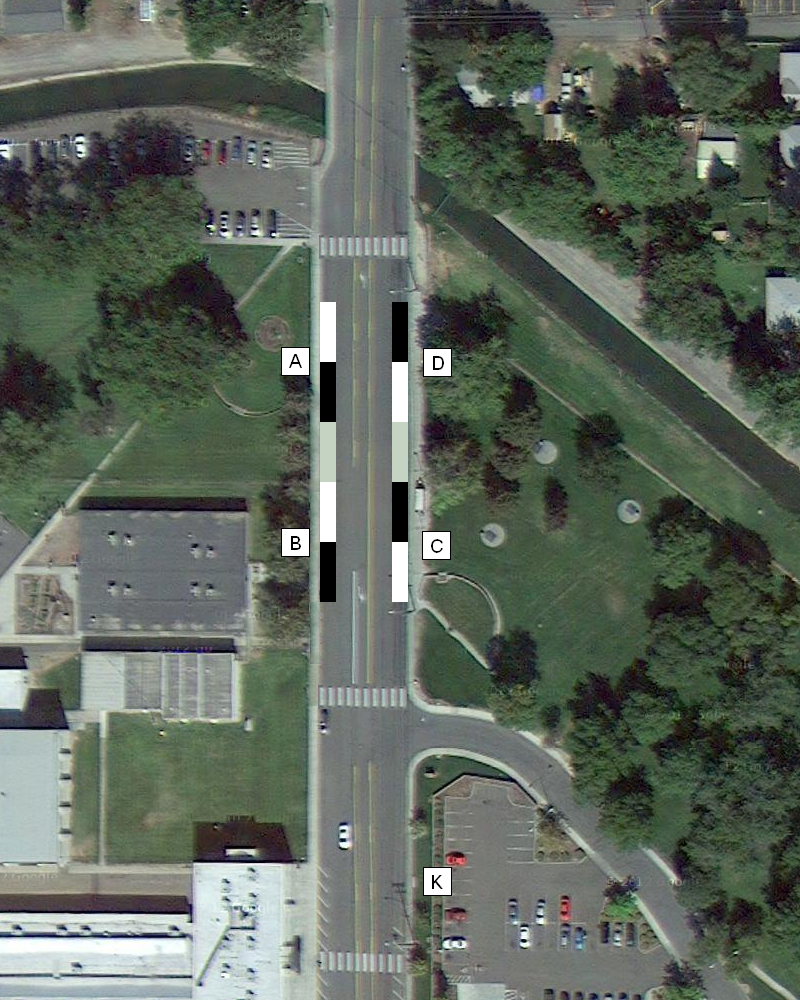
Overhead view of concept for new Dayton Street Transit Center
Instead of buying land and constructing a brand new transit center, we can just keep Dayton Street TC right where it is. Very little would remain the same though if the site was reconstructed though. Unlike the current design of the transit center, buses would stop on both sides of Dayton Street, as the transit center would now be built like a transit mall. (See Redmond Transit Center in Redmond WA to get a better idea of the concept.) Along with having buses stop on both sides of the street, there would also be designated zones for each route, massively improving the current system of a randomly ordered wall of buses (currently the first bus to arrive at Dayton Street TC stages on the north end, then the second bus stages right behind the first bus, and so on). With a zone system, this would also improve passenger accessibility for when BFT is able to increase headways past every 30 minutes (and if I’m being hopeful, the introduction of Sunday service as well). In my proposal, there would be 4 zones, as shown in the graphic, with 2 zones on each side of the street and each zone able to accommodate 2 buses. In the graphic, the black rectangles note the location of the first bus at each zone, while the white rectangles note the location of the second bus. (The grey rectangle notes the 40 feet space between each zone.) There would also be an extra one-bus zone south of Keewaydin Dr next to the library parking lot for reserve bus staging, shuttle service, etc. (It is unforeseeable that there would be a need for more capacity than what is proposed, regardless of service frequency.) Posted speed limits on Dayton Street limit traffic to 25 mph, and it is unlikely that this would need to be changed for the new Dayton Street TC. However, two marked pedestrian crossings would be added on the north and south ends of the transit center to allow passengers and pedestrians a safe crossing. (I did put consideration in to having a marked crosswalk in the middle of the transit center instead, but with the necessary setback from the Keewaydin Dr intersection already in place and the limited area there is to place the bus zones, I didn’t find it feasible or warranted.)
In my proposal, the zone assignments would go as follows:
- Zone A – Route 41 and Route 48 (continuing from Route 42 and 47)
- Zone B – Route 160WB and an extra slot for future route
- Zone C – Route 42 and Route 47 (continuing from Route 41 and Route 48)
- Zone D – Route 160EB and an extra slot for future route
- Zone K – Coach staging and shuttle service
Perhaps the biggest benefit that is gained from simply modifying an existing transit center versus building a completely brand new one is the cost factor. If BFT were to build a new transit center in east Kennewick, there would be the cost of land acquisition, design and engineering, and construction. By simply modifying Dayton Street TC, there would only be a few major capital costs:
- Widened sidewalk – On the east side of Dayton Street at the existing transit center, the sidewalk has been doubled in width. That would be replicated on the west side of the street. The sidewalk widening would be along the length of the Zone A and Zone B with some runoff on the north and south ends, for a length of about 220 feet. The estimated cost for this would be about $45.00 per foot, or $9900 total.
- Lighting and shelters – At the current transfer point, there is one passenger shelter flanked by two lights. This shelter would be the designated shelter for Zone C, while new shelters and lights would be added for Zone A, Zone B, and Zone D. The average cost for a bus stop shelter is about $7,000, while the cost for two lights for each shelter would be about $3,000. The estimated cost for this would be about $10,000 for each zone, or $30,000 total.
- Bus pads – The most costly expenditure for the new transit center. On both sides of the street, the curbside lanes where the buses stage at the 4 zones would be rebuilt with a concrete pad that is 11 feet wide and 10 inches thick. Each pad would be 200 feet in length, covering the 80 feet of each zone along with the 40 foot buffer in between zones. Depending on funds, the pads could be extending north or south to alleviate tension on the asphalt at the base of the pad. The estimated cost for this would be about $128.57 per foot, or $51,428 total.
There would also be the cost of painting the crosswalks and “Bus-Only” lane markings along the zones, and the cost of zone markers. In total, the material cost would be somewhere around $100,000. I won’t try to speculate around the total cost of the project, as I’m not versed in the world of construction contract costs. It is relevant to mention that Intercity Transit (Olympia WA) is still waiting to get the funds necessary to rebuild their downtown transit center at a cost of $8.3 million, a cost that a rebuilt Dayton Street Transit Center would not even come close to approaching.
Once fully built out, there would be some slight modifications to all the routes serving Dayton Street TC. Through the process of realignment, only 6 stops would be closed. All those stops are roughly within a block of other stops that will remain in service, so there is no worry of cutting anyone off from the bus or a Title VI violation. By elimination the one-way routing that is necessitated by the current design of Dayton Street TC, there would also be the opportunity to add 11 new stops (4 of which are from the addition of a deviation to Kennewick General Hospital on Route 48). Finally, there would be just one stop that would need to be moved (also from the addition of the KGH deviation on Route 48). All the current route interlines would remain unchanged. I should note that the zone placement for each route was based upon those interlines. Below is a detailed description of the new directions that each route would follow:
- Route 41 – Inbound routing would remain unchanged. Outbound routing would follow the same path, heading south on Dayton St, east on 6th Ave, north on Auburn St, east on 2nd Ave, south on Washington St, and east on 3rd Ave. New stops would be at the Kennewick PD station (6th Ave), Kennewick Post Office/Senior Center (Auburn St), and at the corner of 2nd Ave and Washington St.
- Route 42 – Inbound routing would delete the turn onto Garfield St, instead continuing east on Vineyard Dr/1st Ave, and south on Dayton St. Outbound routing would remain unchanged. New stop would be at the corner of 1st Ave and Everett St.
- Route 47 – Inbound routing would delete the turn onto 6th Ave, instead continuing north on Garfield St, east on Vineyard Dr/1st Ave, and south on Dayton St. Outbound routing would remain unchanged. New stops would be at Lampson Stadium/St. Joseph’s Church (Garfield St), and at the corner of 1st Ave and Everett St.
- Route 48 – Inbound routing would delete service on part of Dayton St, instead heading north on Dayton St, east on 8th Ave, north on Auburn St, west on 6th Ave, and north on Dayton St. Outbound routing would follow the same path in the opposite direction. New stops would be added at Kennewick General Hospital (8th Ave, both sides), and at Desert Villa Apartments (Auburn St, both sides). The stop at the LDS Seminary (Dayton St) would be moved a block south to Columbia Industries (at the old transfer point).
- Route 160EB – Inbound and Outbound routing would follow the same path, heading east on Kennewick Ave, south on Carmichael Dr/Garfield St, east on 6th Ave, north on Dayton St, stopping at Dayton Street TC, north on Dayton St, east on 1st Ave, and north on Washington St. No new stops would be added.
- Route 160WB – Inbound routing would delete service on Washington St south of 1st Ave, instead heading south on Washington St, west on 1st Ave, south on Dayton St, stopping at Dayton Street TC, south on Dayton St, west on 6th Ave, north on Garfield St/Carmichael Dr, and west on Kennewick Ave. New stops would be added at the corner of 1st Ave and Benton St, Kennewick High School Gym (6th Ave), and at Lampson Stadium/St. Joseph’s Church (Garfield St).
Like my previous posts on revamping the BFT system or even just making subtle changes, I do believe that this proposal for a new Dayton Street TC is feasible. I’ll admit, my thinking on this has probably been somewhat influenced by my multiple changes in locale last year and the subsequent crash courses I got in the bus-only transit systems of other metros. Regardless, the fact is that 2nd-rate transit infrastructure will not cut it anymore. As this country reaches a turning point where more and more people are starting to discover the benefits of transit, we need to make more investments in our transit infrastructure for today and for the future. Making the investment to bring Dayton Street TC in line with modern standards is a small step in that direction for BFT and the City of Kennewick. Politically, it also shows that the Tri-Cities can be a pro-transit metro, which is big when you consider that a large majority of the poplace is politically conservative. As I touched on earlier in the post, this project also increase ease of access for BFT passengers, which is the main reason that I believe this project is worth undertaking.
So, what do you think? Would my proposal work, or do you think there’s a better option? Leave a comment below, or let me know on Twitter by tweeting @ziggzagzac.


Your proposal is well thought out. Would the transfer center make the street one way? It seems that while changing the traffic flow in that area, making it a one way street, would eliminate some confusion on the part of people driving through the area.
Thank you. The new transit center would leave the traffic flow on Dayton Street the same as it is now, with one traffic lane in each direction and the center turn lane in the middle. Making Dayton Street one-way would not work in this proposal, as it would require the construction of a concrete island on one side to allow transit passengers safe egress from the bus.