Transit Throwback – 1980 Spokane Transit System Tourmap
Posted: May 22, 2014 Filed under: Transit Throwback 3 CommentsOn April 10 1979, The Spokesman-Review included a small blurb in the newspaper that day on a new transit map.
A multicolored bus tour map, showing routes and places of interest, will be distributed to passengers by Spokane Transit System drivers, starting today. Basically, the maps show Spokane locations.
What the S-R was referring to was a brand new system map that had been designed by Dick and Marjorie Ingalls of the Tourmap Company, located right in Spokane. Depending on the source, this was actually the first full-system map for a bus company in Spokane, or at least among the very first attempts. The next year, the Tourmap Company published the Spokane Transit System Tourmap again, which saw little to no changes from the 1979 version. Again, the map was distributed to riders aboard STS buses.
Thanks to the Spokane Public Library, a copy of both the 1979 and 1980 maps are preserved to this date, the latter of which you can see below. (Click this link to view full size version.)
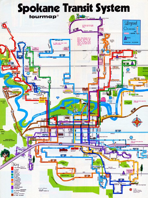
Those familiar with the present STA system will probably immediately notice the stark differences in the STS system from 1980. Many routes took circuitous trips through city neighborhoods, winding and weaving along narrow streets. Much like the current practice of interlining bus routes at The Plaza in downtown, every bus route was “through-routed” between one side of the city and the other on Riverside Avenue, with the exception of Line 6 and Line 9 (just like the 25 and 90 continue to do today). Like the streetcars did back in the early part of the century, the main transfer point was at the corner of Howard Street and Riverside Avenue. Many of the line names also used the neighborhood names, like Cable Addition or Hollywood, and not street names, a practice that continued until a major system revision in 1998.
Transit history fans will notice the inclusion of GM New Looks, or “Fishbowls,” on the map as well. Along every line is a bus colored to match the route it’s on. STS did have some GM RTS buses at that time as well, but with 48 New Looks in the fleet, that was the bus that most riders were familiar with. The only one on the map to actually match the appearance of the STS buses is located on Boone Avenue, next to the label for Spokane Transit System and the Lost and Found.
If you look closely at the map, you’ll notice a lot of notable Spokane landmarks included, such as the US Pavilion in Riverfront Park (which notably is show with the old vinyl roof), the clocktower from the former Great Northern Railroad transit station that used to occupy most all of Havermale Island before Expo ’74, and even the now-defunct Spokane Coliseum. As this was designed to be used as a tourmap, other key landmarks located include multiple medical facilities, public parks and swimming pools, and all junior high/high schools and colleges/universities.
Compare it with the current incarnation of the STA system map, and you can see that we’ve come a long way since 1980. For all intents and purposes, this map served its purpose quite well. If nothing else, it was a colorful source of information for STS riders, something that was largely absent in Spokane for a long time. As I mentioned earlier, this map is still preserved thanks to the Spokane Public Library, and so I want to say thank you to SPL and especially the staff of the Northwest Room.
As this map was before my time, I welcome any comments and input on anything related to it. I will also mention that this is not the only historical Spokane transit map in the Transit 509 archives, so keep an eye out for more in the near future!


Thanks for posting this. Brings back memories. I used to have one of those maps. And yes, put in a lot of miles on those GM New Looks.
This is wonderful. Favor to ask — is there any way you could get me the route list that’s on this map + Cheney/EWU, Medical Lake, etc?
[…] to the current Spokane bus map by CHK America (February 2012, 4 […]