More ZEPS Electric Buses On The Way?
Posted: June 14, 2013 Filed under: Transit | Tags: ben franklin transit, Complete Coach Works, Electric Bus, ZEPS Leave a commentBack in October, I first reported on the BFT Electric Bus Demonstration project. Since that time, there have been some updates. Perhaps the biggest and most important is that the ZEPS Electric Bus was finally delivered on the evening of May 13th. Am I late in reporting this? You bet. However, I was trying to hold off on writing a post about this until I had a chance to get a close up look at the ZEPS Electric Bus and take some photos. However, after last night’s BFT board meeting, I figured I needed to share the latest update to this project, because it is a big deal.
After word got around about what Ben Franklin Transit was doing, other agencies got interested. Rather rapidly, a consortium of interested agencies formed, and now an application for a TIGER (Transportation Investment Generating Economic Recovery) Grant has been submitted. Officially submitted on June 3rd, the application is submitted under the name “US Bus – National Long Range Electric Bus Deployment Partnership.” BFT is the lead agency on this proposal, but there are quite a few partner agencies:
- CALSTART (Pasadena CA)*
- Clallam Transit (Port Angeles WA)
- Washington State Department of Transportation (Olympia WA)**
- Berks Area Regional Transportation Authority [BARTA] (Reading PA)
- Santa Cruz Metropolitan Transit District [Santa Cruz Metro] (Santa Cruz CA)
- Lane Transit District (Eugene OR)
- East Contra Costa Transit Authority [Tri-Delta Transit] (Antioch CA)
- Indianapolis Public Transportation Corporation [IndyGo] (Indianapolis IN)
- OmniTrans (San Bernardino CA)
- Gardena Municipal Bus Lines (Gardena CA)***
- New York Metropolitan Transportation Authority (New York NY)
- Kansas City International Airport (Kansas City MO)
* – CALSTART was the grantee of the funds for the original BFT Zeps Electric Bus
** – WSDOT is acting as a steward for rural agencies in WA, will distribute buses to 4-5 agencies
*** – Gardena Municipal Bus Lines runs the demonstration ZEPS Electric Bus built by Complete Coach Works
Included in the TIGER Grant application are letters of support from all the participating agencies, along with letters of support from Senator Richard D. Roth (31st District CA), Michael Kluse (Director of Pacific Northwest National Labratory), Joseph K. Lyou, Ph.D. (President and CEO of Coalition for Clean Air), and Larry Rubio (CEO of Riverside Transit Agency).
Between all the different agencies, the proposal is for 41 buses to be built. All agencies (not counting CALSTART) will be providing at least 2 buses to be rebuilt as ZEPS Electric Buses. The grant funds will pay for the installation of charging stations and subsidize operating costs, with each agency providing their own local match. As the lead agency in this project, BFT will also be adding some additional infrastructure. The most noticeable part will be the installation of a solar array above the bus yard, which will be used to power the electric charging stations (this will be the 1st in the US, 5th internationally). BFT will also be working in collaboration with Columbia Basin College (CBC) to develop the “US Zero Emission Bus Center of Excellence,” which will be a resource and training/research center for agencies across the country.
While the participating agencies are only “ankle-deep” into this project at this point, I think the likelihood of this TIGER Grant being approved is highly likely. If it is approved, it will be a game changer for all the participating agencies, but especially for lead agency Ben Franklin Transit. For all we know, this may be just a small first step into the future of transit.
UPDATE 9/5/13: The final list of TIGER grant awards for 2013 has been released today, and sadly this project was not on the list. Looking back on it, there are several possible reasons as to why the “US Bus – National Long Range Electric Bus Deployment Partnership” was not selected. For starters, if approved it would have been the largest TIGER grant this year, at over $39 million. (There have only been 12 grants over that amount in the history of the TIGER program, 11 in 2009 and 1 in 2010.) Also, the multitude of agencies involved in this grant application may have been an issue, as there is not a whole lot of precedence for multiple agencies/jurisdictions in the TIGER program. All past TIGER grants that did involve multiple agencies/jurisdictions were neighbors and shared a common interest, such as the Mississippi River Bridges ITS application in 2011 that involved Mississippi, Arkansas, and Lousiana, or the Memorial Bridge Replacement application in Portsmouth NH and Kittery ME from 2010. Finally, it is worth noting that the most successful TIGER grants have a lot of local and financial support, and it’s not very clear if this consortium of agencies had that. It’s assumed that all the involved agencies accepted the proposed costs of this plan, but some of them may not have had the money budgeted away for a local match. As noted in this post originally, this consortium formed rather rapidly before the June 3rd application deadline, so there wasn’t much time to drum up major support for this project.
Even though this project will not be happening, there still is good news to come out of today’s final list of TIGER grants. Previously unknown to myself or fellow blogger Curt Ailes at Urban Indy, IndyGo (the local transit agency in Indianapolis) applied for and was awarded $10 million for at least 22 electric buses. The official press release explains more about the project:
INDIANAPOLIS (September 5, 2013) – This morning, the Federal Transit Administration (FTA) announced the award of $10M in Transportation Investment Generating Economic Recovery (TIGER) funds to IndyGo, the public transit agency for Indianapolis, Indiana. The highly competitive grant program prioritizes transportation projects that have significant impact on outcomes relating to state of good repair, economic competitiveness, livability, environmental sustainability and safety of the nation’s transportation infrastructure. The award of these funds will allow IndyGo to recondition and repower upwards of 22 transit vehicles, employing a zero-emissions electric propulsion system.
“As a strong proponent of improving transit for Hoosiers, I was glad to lend my support to this effort,” said Congressman André Carson. “Recycling used buses to make them fully electric will save us money, reduce waste, energy consumption and dependence on foreign oil, and maintain a quality transit system for years to come.”
The 22 remanufactured electric propulsion transit buses will be completely rebuilt to like-new condition with a zero-emissions drive system and will cost approximately $555,000 each, comparable to a brand new diesel bus. In addition to the cost to rebuild and repower the vehicles, the grant also funds necessary charging stations at the IndyGo facility and the Transit Center, which is set to open in late 2015.
“Today’s announcement of the TIGER grant award supports our city’s goal to reduce dependence on foreign oil,” said Greg Ballard, Mayor of Indianapolis. “By introducing zero emission, post-oil technology public transit buses, we’re making another successful leap in the right direction.”
The new electric buses will have a range of approximately 100 miles and will provide the equivalent of 16 MPG, quadruple the energy efficiency of a conventional diesel bus. The 22 new electric vehicles will be used on routes that are compatible with the range limitations and will allow IndyGo to retire some of its older buses.
“IndyGo is thrilled to have the opportunity to be on the leading edge of the transit industry with the project,” said Michael terry, IndyGo President and CEO. “We’re always investigating innovative ways to refresh our fleet and use technology to build capacity with the limited funds that are available to operate vital transit services.”
For project updates and other news, visit IndyGo.net.
While not spelled out in the press release, it is clearly apparent that these will be ZEPS Electric Buses built by Complete Coach Works. For a refresher, this is same type of electric bus that Ben Franklin Transit is currently running and the same type that the consortium of agencies was going to use. While I am disappointed that we won’t be seeing more ZEPS Buses in the Tri-Cities (or at least not yet), it is quite exciting to see other agencies taking the plunge and investing in this type of electric bus. This is a big deal for Complete Coach Works, as this will be the first multi-bus order of the ZEPS Bus. As previously mentioned before, there are only two ZEPS Buses in existence currently, one operating as a demonstration unit and sometimes part of the Gardena Municipal Bus Lines fleet while the bus at BFT is the first official production unit. The demonstration unit made an appearance at the APTA Conference earlier this year in Indianapolis, which likely sold officials at IndyGo on the technology. Based on the positive reception that the ZEPS Bus has received here in the Tri-Cities, I think it’ll do quite well in Indianapolis.
MetroRapid – What is Tampa Really Getting?
Posted: May 20, 2013 Filed under: Transit | Tags: BRT, MetroRapid, North-South, schedule, Tampa 4 CommentsAfter months of planning and work, the first BRT line in the history of the Tampa Bay area is set to launch on May 28th.

A map showing the proposed BRT and light rail network.
When the Hillsborough light rail referendum failed at the polls in 2010, HART changed their plans and started moving forward with plans for a BRT (bus rapid transit) system to be overlaid over the existing bus network, which included expanding service into new parts of Hillsborough County. While more of a consolation prize for the light rail network that advocates had been hoping for, it was hoped that a BRT network would be the start of the future HCT (high capacity transit) network that would span the entire Tampa Bay area.
With funding extremely limited due to current budget constraints, HART is currently rolling out the network in pieces, starting with the “North-South” line, which is largely an overlay of the currently existing Route 2 running between Marion TC and University Area TC along Nebraska Ave and Fletcher Ave. Unlike Route 2, the North-South line will continue east on Fletcher Ave past UATC to serve the Hidden River area, a part of Hillsborough County that has never had fixed route service before. In early planning, HART was anticipating that the North-South line would run every 10 minutes during peak hours and every 15 minutes during off-peak hours, but that was later rolled back to every 15 minutes all day. Though it’s not clear if HART ever had plans for service every day of the week in the initial stages of planning, the final schedules only have the North-South line running on weekdays between 5AM-8PM. As part of the realignment in service along the Nebraska Ave corridor, incumbent Route 2 is having weekday frequency rolled back from the current every 15 minutes peak/every 20 minutes off-peak to every 30 minutes all day, with late night service frequencies unchanged. It is worth noting however that HART has indicated that the old Route 2 schedule will remain in effect until June 10th, 2 weeks after the North-South line begins service (The summer markup goes into effect May 26th.)
Below, I have the schedules for the North-South line.
MTC = Marion Transit Center
NEB/COL = Nebraska Ave and Columbus Drive
NEB/MLK = Nebraska Ave and Martin Luther King Jr. Blvd
NEB/HILL = Nebraska Ave and Hillsborough Ave
NEB/BUS = Nebraska Ave and Busch Blvd
NEB/FLET = Nebraska Ave and Fletcher Ave
UATC = University Area Transit Center
HDRV = Hidden River Park-and-Ride
NORTHBOUND
|
|||||||
MTC
|
NEB/COL
|
NEB/MLK
|
NEB/HILL
|
NEB/BUS
|
NEB/FLET
|
UATC
|
HDRV
|
| 5:00 | 5:13 | 5:16 | 5:20 | 5:29 | 5:39 | 5:45 | 6:09 |
| 5:15 | 5:28 | 5:31 | 5:35 | 5:44 | 5:54 | 6:00 | — |
| 5:30 | 5:43 | 5:46 | 5:50 | 5:59 | 6:09 | 6:15 | 6:39 |
| 5:45 | 5:58 | 6:01 | 6:05 | 6:14 | 6:24 | 6:30 | — |
| 6:00 | 6:13 | 6:16 | 6:20 | 6:29 | 6:39 | 6:45 | 7:09 |
| 6:15 | 6:28 | 6:31 | 6:35 | 6:44 | 6:54 | 7:00 | — |
| 6:30 | 6:43 | 6:46 | 6:50 | 6:59 | 7:09 | 7:15 | 7:39 |
| 6:45 | 6:58 | 7:01 | 7:05 | 7:14 | 7:24 | 7:30 | — |
| 7:00 | 7:13 | 7:16 | 7:20 | 7:29 | 7:39 | 7:45 | 8:09 |
| 7:15 | 7:28 | 7:31 | 7:35 | 7:44 | 7:54 | 8:00 | — |
| 7:30 | 7:43 | 7:46 | 7:50 | 7:59 | 8:09 | 8:15 | 8:39 |
| 7:45 | 7:58 | 8:01 | 8:05 | 8:14 | 8:24 | 8:30 | — |
| 8:00 | 8:13 | 8:16 | 8:20 | 8:29 | 8:39 | 8:45 | 9:09 |
| 8:15 | 8:28 | 8:31 | 8:35 | 8:44 | 8:54 | 9:00 | — |
| 8:30 | 8:43 | 8:46 | 8:50 | 8:59 | 9:09 | 9:15 | 9:39 |
| 8:45 | 8:58 | 9:01 | 9:05 | 9:14 | 9:24 | 9:30 | — |
| 9:00 | 9:13 | 9:16 | 9:20 | 9:29 | 9:39 | 9:45 | 10:09 |
| 9:15 | 9:28 | 9:31 | 9:35 | 9:44 | 9:54 | 10:00 | — |
| 9:30 | 9:43 | 9:46 | 9:50 | 9:59 | 10:09 | 10:15 | 10:39 |
| 9:45 | 9:58 | 10:01 | 10:05 | 10:14 | 10:24 | 10:30 | — |
| 10:00 | 10:13 | 10:16 | 10:20 | 10:29 | 10:39 | 10:45 | 11:09 |
| 10:15 | 10:28 | 10:31 | 10:35 | 10:44 | 10:54 | 11:00 | — |
| 10:30 | 10:43 | 10:46 | 10:50 | 10:59 | 11:09 | 11:15 | 11:39 |
| 10:55 | 11:08 | 11:11 | 11:15 | 11:24 | 11:34 | 11:40 | — |
| 11:00 | 11:13 | 11:16 | 11:20 | 11:29 | 11:39 | 11:45 | 12:09 |
| 11:15 | 11:28 | 11:31 | 11:35 | 11:44 | 11:54 | 12:00 | — |
| 11:30 | 11:43 | 11:46 | 11:50 | 11:59 | 12:09 | 12:15 | 12:39 |
| 11:45 | 11:58 | 12:01 | 12:05 | 12:14 | 12:24 | 12:30 | — |
| 12:00 | 12:13 | 12:16 | 12:20 | 12:29 | 12:39 | 12:45 | 1:09 |
| 12:15 | 12:28 | 12:31 | 12:35 | 12:44 | 12:54 | 1:00 | — |
| 12:30 | 12:43 | 12:46 | 12:50 | 12:59 | 1:09 | 1:15 | 1:39 |
| 12:45 | 12:58 | 1:01 | 1:05 | 1:14 | 1:24 | 1:30 | — |
| 1:00 | 1:13 | 1:16 | 1:20 | 1:29 | 1:39 | 1:45 | 2:09 |
| 1:15 | 1:28 | 1:31 | 1:35 | 1:44 | 1:54 | 2:00 | — |
| 1:30 | 1:43 | 1:46 | 1:50 | 1:59 | 2:09 | 2:15 | 2:39 |
| 1:45 | 1:58 | 2:01 | 2:05 | 2:14 | 2:24 | 2:30 | — |
| 2:00 | 2:13 | 2:16 | 2:20 | 2:29 | 2:39 | 2:45 | 3:09 |
| 2:15 | 2:28 | 2:31 | 2:35 | 2:44 | 2:54 | 3:00 | — |
| 2:30 | 2:43 | 2:46 | 2:50 | 2:59 | 3:09 | 3:15 | 3:39 |
| 2:45 | 2:58 | 3:01 | 3:05 | 3:14 | 3:24 | 3:30 | — |
| 3:00 | 3:13 | 3:16 | 3:20 | 3:29 | 3:39 | 3:45 | 4:09 |
| 3:15 | 3:28 | 3:31 | 3:35 | 3:44 | 3:54 | 4:00 | — |
| 3:30 | 3:43 | 3:46 | 3:50 | 3:59 | 4:09 | 4:15 | 4:39 |
| 3:45 | 3:58 | 4:01 | 4:05 | 4:14 | 4:24 | 4:30 | — |
| 4:00 | 4:13 | 4:16 | 4:20 | 4:29 | 4:39 | 4:45 | 5:09 |
| 4:15 | 4:28 | 4:31 | 4:35 | 4:44 | 4:54 | 5:00 | — |
| 4:30 | 4:43 | 4:46 | 4:50 | 4:59 | 5:09 | 5:15 | 5:39 |
| 4:45 | 4:58 | 5:01 | 5:05 | 5:14 | 5:24 | 5:30 | — |
| 5:00 | 5:13 | 5:16 | 5:20 | 5:29 | 5:39 | 5:45 | 6:09 |
| 5:15 | 5:28 | 5:31 | 5:35 | 5:44 | 5:54 | 6:00 | — |
| 5:30 | 5:43 | 5:46 | 5:50 | 5:59 | 6:09 | 6:15 | 6:39 |
| 5:45 | 5:58 | 6:01 | 6:05 | 6:14 | 6:24 | 6:30 | — |
| 6:00 | 6:13 | 6:16 | 6:20 | 6:29 | 6:39 | 6:45 | 7:09 |
| 6:15 | 6:28 | 6:31 | 6:35 | 6:44 | 6:54 | 7:00 | — |
| 6:30 | 6:43 | 6:46 | 6:50 | 6:59 | 7:09 | 7:15 | 7:39 |
| 6:45 | 6:58 | 7:01 | 7:05 | 7:14 | 7:24 | 7:30 | — |
SOUTHBOUND
|
|||||||
HDRV
|
UATC
|
NEB/FLET
|
NEB/BUS
|
NEB/HILL
|
NEB/MLK
|
NEB/COL
|
MTC
|
| — | 5:20 | 5:30 | 5:39 | 5:48 | 5:51 | 5:55 | 6:05 |
| 5:15 | 5:35 | 5:45 | 5:54 | 6:03 | 6:06 | 6:10 | 6:20 |
| — | 5:50 | 6:00 | 6:09 | 6:18 | 6:21 | 6:25 | 6:35 |
| 5:45 | 6:05 | 6:15 | 6:24 | 6:33 | 6:36 | 6:40 | 6:50 |
| — | 6:20 | 6:30 | 6:39 | 6:48 | 6:51 | 6:55 | 7:05 |
| 6:15 | 6:35 | 6:45 | 6:54 | 7:03 | 7:06 | 7:10 | 7:20 |
| — | 6:50 | 7:00 | 7:09 | 7:18 | 7:21 | 7:25 | 7:35 |
| 6:45 | 7:05 | 7:15 | 7:24 | 7:33 | 7:36 | 7:40 | 7:50 |
| — | 7:20 | 7:30 | 7:39 | 7:48 | 7:51 | 7:55 | 8:05 |
| 7:15 | 7:35 | 7:45 | 7:54 | 8:03 | 8:06 | 8:10 | 8:20 |
| — | 7:50 | 8:00 | 8:09 | 8:18 | 8:21 | 8:25 | 8:35 |
| 7:45 | 8:05 | 8:15 | 8:24 | 8:33 | 8:36 | 8:40 | 8:50 |
| — | 8:20 | 8:30 | 8:39 | 8:48 | 8:51 | 8:55 | 9:05 |
| 8:15 | 8:35 | 8:45 | 8:54 | 9:03 | 9:06 | 9:10 | 9:20 |
| — | 8:50 | 9:00 | 9:09 | 9:18 | 9:21 | 9:25 | 9:35 |
| 8:45 | 9:05 | 9:15 | 9:24 | 9:33 | 9:36 | 9:40 | 9:50 |
| — | 9:20 | 9:30 | 9:39 | 9:48 | 9:51 | 9:55 | 10:05 |
| 9:15 | 9:35 | 9:45 | 9:54 | 10:03 | 10:06 | 10:10 | 10:20 |
| — | 9:50 | 10:00 | 10:09 | 10:18 | 10:21 | 10:25 | 10:35 |
| 9:45 | 10:05 | 10:15 | 10:24 | 10:33 | 10:36 | 10:40 | 10:50 |
| — | 10:20 | 10:30 | 10:39 | 10:48 | 10:51 | 10:55 | 11:05 |
| 10:15 | 10:35 | 10:45 | 10:54 | 11:03 | 11:06 | 11:10 | 11:20 |
| — | 10:50 | 11:00 | 11:09 | 11:18 | 11:21 | 11:25 | 11:35 |
| 10:45 | 11:05 | 11:15 | 11:24 | 11:33 | 11:36 | 11:40 | 11:50 |
| — | 11:20 | 11:30 | 11:39 | 11:48 | 11:51 | 11:55 | 12:05 |
| 11:15 | 11:35 | 11:45 | 11:54 | 12:03 | 12:06 | 12:10 | 12:20 |
| — | 11:50 | 12:00 | 12:09 | 12:18 | 12:21 | 12:25 | 12:35 |
| 11:45 | 12:05 | 12:15 | 12:24 | 12:33 | 12:36 | 12:40 | 12:50 |
| — | 12:20 | 12:30 | 12:39 | 12:48 | 12:51 | 12:55 | 1:05 |
| 12:15 | 12:35 | 12:45 | 12:54 | 1:03 | 1:06 | 1:10 | 1:20 |
| — | 12:50 | 1:00 | 1:09 | 1:18 | 1:21 | 1:25 | 1:35 |
| 12:45 | 1:05 | 1:15 | 1:24 | 1:33 | 1:36 | 1:40 | 1:50 |
| — | 1:20 | 1:30 | 1:39 | 1:48 | 1:51 | 1:55 | 2:05 |
| 1:15 | 1:35 | 1:45 | 1:54 | 2:03 | 2:06 | 2:10 | 2:20 |
| — | 1:50 | 2:00 | 2:09 | 2:18 | 2:21 | 2:25 | 2:35 |
| 1:45 | 2:05 | 2:15 | 2:24 | 2:33 | 2:36 | 2:40 | 2:50 |
| — | 2:20 | 2:30 | 2:39 | 2:48 | 2:51 | 2:55 | 3:05 |
| 2:15 | 2:35 | 2:45 | 2:54 | 3:03 | 3:06 | 3:10 | 3:20 |
| — | 2:50 | 3:00 | 3:09 | 3:18 | 3:21 | 3:25 | 3:35 |
| 2:45 | 3:05 | 3:15 | 3:24 | 3:33 | 3:36 | 3:40 | 3:50 |
| — | 3:20 | 3:30 | 3:39 | 3:48 | 3:51 | 3:55 | 4:05 |
| 3:15 | 3:35 | 3:45 | 3:54 | 4:03 | 4:06 | 4:10 | 4:20 |
| — | 3:50 | 4:00 | 4:09 | 4:18 | 4:21 | 4:25 | 4:35 |
| 3:45 | 4:05 | 4:15 | 4:24 | 4:33 | 4:36 | 4:40 | 4:50 |
| — | 4:20 | 4:30 | 4:39 | 4:48 | 4:51 | 4:55 | 5:05 |
| 4:15 | 4:35 | 4:45 | 4:54 | 5:03 | 5:06 | 5:10 | 5:20 |
| — | 4:50 | 5:00 | 5:09 | 5:18 | 5:21 | 5:25 | 5:35 |
| 4:45 | 5:05 | 5:15 | 5:24 | 5:33 | 5:36 | 5:40 | 5:50 |
| — | 5:20 | 5:30 | 5:39 | 5:48 | 5:51 | 5:55 | 6:05 |
| 5:15 | 5:35 | 5:45 | 5:54 | 6:03 | 6:06 | 6:10 | 6:20 |
| — | 5:50 | 6:00 | 6:09 | 6:18 | 6:21 | 6:25 | 6:35 |
| 5:45 | 6:05 | 6:15 | 6:24 | 6:33 | 6:36 | 6:40 | 6:50 |
| — | 6:20 | 6:30 | 6:39 | 6:48 | 6:51 | 6:55 | 7:05 |
| 6:15 | 6:35 | 6:45 | 6:54 | 7:03 | 7:06 | 7:10 | 7:20 |
| — | 6:50 | 7:00 | 7:09 | 7:18 | 7:21 | 7:25 | 7:35 |
| 6:45 | 7:05 | 7:15 | 7:24 | 7:33 | 7:36 | 7:40 | 7:50 |
| — | 7:20 | 7:30 | 7:39 | 7:48 | 7:51 | 7:55 | 8:05 |
A few quick facts about the schedule:
- Northbound service will see 56 trips, while southbound service will see 57 trips.
- With the exception of the 10:55AM NB trip, the North-South line has been scheduled to keep buses spaced at 15 minute intervals throughout the day.
- Though it takes a bit of a closer look, the schedules show that 9 MetroRapid buses will be in service each day (12 were purchased, so 3 will remain as operational spares.)
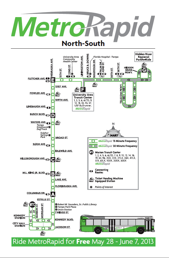
Map for the MetroRapid North-South Line
One immediate issue that can be noticed is the 30 minute headways between UATC and Hidden River Park-and-Ride. While I can’t say that HART never disclosed this fact (though its not exactly easy to find any mentions of it), I’m fairly certain that many if not most of the potential riders on the North-South line are going to be unaware of this. Apart from the various employment centers in Telecom Park, the main draw in this area will be the park-and-ride, which has 320 spaces. Officials at HART have indicated that the hope for this park-and-ride is to draw people currently commuting from the northern suburbs along I-75 to transit. Currently, there is a park-and-ride operating about 3 miles to the north using the parking lot at Lowe’s. There are also two other park-and-ride lots further north, both which use the parking lots of churches in neighboring Pasco County. With only two AM trips and two PM trips in the peak direction on Route 51X, there isn’t much demand for service in this area currently. As of February, Route 51X is only average 16.2 passengers per trip, so it’s a bit of a “hail mary” to hope that commuters will be drawn to this new park-and-ride facility with the all-day transit service.
Another issue that the North-South line will be facing is one that many other recently instituted BRT operations in the US face: mixed-traffic operations. Along most of the North-South line, there is no separation of buses and other traffic on the road. On Nebraska Ave between Cass Street and Hillsborough Ave, there are intermittent bus lanes that were put into place as a result of the Nebraska Avenue road diet project. However, few bus operators make use of them and its not clear if there is an official HART policy regarding them. With no form of separation from traffic, the potential time savings on the North-South line is not much when compared to the Route 2 schedule. Below is a comparison of the scheduled time between each shared time point on the North-South line and Route 2. (Note that the time between UATC and Hidden River is not shown since no other routes run there currently.)
|
NORTHBOUND
|
|||
| Route 2 | North-South | Time Saved | |
| MTC-NEB/COL | 7 | 13 | +6 |
| NEB/COL-NEB/MLK | 4 | 3 | -1 |
| NEB/MLK-NEB/HILL | 5 | 4 | -1 |
| NEB/HILL-NEB/BUS | 11 | 9 | -2 |
| NEB/BUS-NEB/FLET | 12 | 10 | -2 |
| NEB/FLET-UATC | 10 | 6 | -4 |
| TOTAL | 49 | 45 | -4 minutes |
|
SOUTHBOUND
|
|||
| Route 2 | North-South | Time Saved | |
| UATC-NEB/FLET | 10 | 10 | 0 |
| NEB/FLET-NEB/BUS | 12 | 9 | -3 |
| NEB/BUS-NEB/HILL | 12 | 9 | -3 |
| NEB/HILL-NEB/MLK | 4 | 3 | -1 |
| NEB/MLK-NEB/COL | 5 | 4 | -1 |
| NEB/COL-MTC | 7 | 10 | +3 |
| TOTAL | 50 | 45 | -5 minutes |
*(Note that the additional time on the North-South line between MTC and Nebraska/Columbus is because it runs down the Marion Street Transitway and through downtown, and Route 2 does not.)
Arguably, the time savings isn’t that great, even though the North-South line only has 23 stops northbound and 24 stops southbound between MTC and UATC (compared with Route 2’s 74 stops northbound and 73 stops southbound). However, it does fit in with the 10-15% time savings that officials have been advertising. To help improve the North-South line’s performance, TSP (transit signal priority) will be used on selected segments. The first TSP segment is on Nebraska Avenue between Cass Street and Floribraska Avenue, and the second TSP segment is on Fletcher Avenue between Nebraska Avenue and 42nd Street/Palm Avenue. On the Nebraska segment, there are 7 stoplights with TSP: Cass, Scott, Henderson, 7th, Palm, Columbus, and Floribraska. On the Fletcher segment, there are 8 stoplights with TSP: Nebraska, 15th, 22nd, Livingston, Bruce B. Downs, Magnolia, 42nd, and Palm. It has been indicated that there are plans to install TSP on the other 36 stoplights along the North-South line.
Along the North-South line, riders will see three different styles of stations: “A,” “B,” and “C.” All three station types feature similar features, with MetroRapid-branded shelter along with a wayfinding totem. The”A” station is the most basic design, with just a shelter awning and a information board. The “B” station features a larger shelter and seating as well. Also important is that the “B” station is designed to have a TVM (ticket vending machine) installed, though only one pair of “B” stations will have them at the opening of the North-South line (Magnolia). For most of the stops, a “B” station has been installed, partly because they can be later upgraded to a “C” station in the future. With a larger shelter than the “B” station and TVM’s located at every one of them, the stops with a “C” station are those that are anticipated to produce the highest ridership. Along with MTC, Jackson/Pierce in downtown, UATC, and Hidden River Park-and-Ride, there are just four “C” station pairs: Martin Luther King Jr. Blvd, Hillsborough Ave, Waters Ave, and Fowler Ave.
With just 14 TVM’s currently in place along the North-South line, any sort of off-board payment system is going to be largely unattainable. As of this writing, there has been no announcement from HART regarding fare payment policies for MetroRapid, so one is left to assume it will be the same as the current policy for regular fixed-route service: Boarding through the front doors only, where riders can pay with cash or swipe their farecards. HART is anticipating that a large majority of the current riders on Route 2 will start using the North-South line. However, without a major change to fare payment policy, the North-South line is likely destined to become bogged down by cash fare payments just as Route 2 does currently. It is important to note that HART recently announced a plan for a major farebox upgrade that will support the use of smart cards (along with the possibility of inter-agency cooperation with PSTA and other neighboring agencies), so there may be hope for the future.
With all the potential issues it faces, I find myself cautiously optimistic about the beginning of the North-South line. It does have a heavy ridership base to build upon (as Route 2 is HART’s busiest route, averaging ~4,300 passengers per day), and with continued growth along the Nebraska Avenue corridor that number can only go higher. As an actual BRT route, it has a long way to go, but as mentioned earlier there are budgetary constraints and so this is about all that can be done at this point. I do fear that regardless of failure or success, the MetroRapid system may end up plotting the destiny for the future of transit in Tampa Bay. If it were to fail, naysayers could point to it and say that it proves there’s not a need to expand transit in the area. If it did succeed past expectations, then it would be harder for advocates to press for more.
At this point, all we can do is wait and see.
UPDATE 8/8/13: Since originally uploading this post, there have been some changes made to the MetroRapid North-South line.
Back on June 7th, HART announced that effective immediately, the North-South line would not be using the Marion Street Transitway, but rather Morgan Street (one block east). With the beginning of the next mark-up (service change) on August 18th, this detour will officially become permanent. I’m not at all surprised that this was done, as I fully expected that MetroRapid buses would become bogged down on the Transitway as every other bus already does due to traffic signals running on a timer system. Unless HART and the City of Tampa find a way to solve this issue, I doubt that the North-South line will be returning to the Transitway.
With the next markup, there will also be some changes to the schedule. Perhaps most notable is that you can now find the *full* schedule on HART’s website, but there’s no word as of yet if the pamphlets will have a full schedule or at least something a little more extensive compared to the current one. With the Nebraska/Columbus and Nebraska/Fletcher timepoints being deleted from the schedule and other minor changes to reflect actual operating conditions, the North-South line will also be running a little faster now. A summary of the schedule change is below:
|
NORTHBOUND
|
|||
| Current | New | Time Saved | |
| MTC-NEB/MLK | 16 | 14 | -2 |
| NEB/MLK-NEB/HILL | 4 | 4 | 0 |
| NEB/HILL-NEB/BUS | 9 | 9 | 0 |
| NEB/BUS-UATC | 16 | 14 | -2 |
| UATC-HDRV | 24 | 23 | -2 |
| TOTAL | 69 | 64 | -5 minutes |
|
SOUTHBOUND
|
|||
| Current | New | Time Saved | |
| HDRV-UATC | 20 | 19 | -1 |
| UATC-NEB/BUS | 19 | 18 | -1 |
| NEB/BUS-NEB/HILL | 9 | 9 | 0 |
| NEB/HILL-NEB/MLK | 3 | 3 | 0 |
| NEB/MLK-MTC | 14 | 12 | -2 |
| TOTAL | 65 | 61 | -4 minutes |
Also note that the issue with the 10:55 northbound trip has been fixed and it now leaves Marion TC at 10:45.
*All the information shown in this post is an aggregation of publicly available data and cannot be claimed as copyrighted or proprietary.
ROUTE CHANGE – Route 47
Posted: May 14, 2013 Filed under: Transit Leave a commentIn response to two separate requests for service, Route 47 will be seeing some temporary changes during this summer, along with the introduction of a brand new route.
The change to Route 47 will begin on Monday, May 20, while the new Route 810 will start service on June 10.
Southridge Deviation
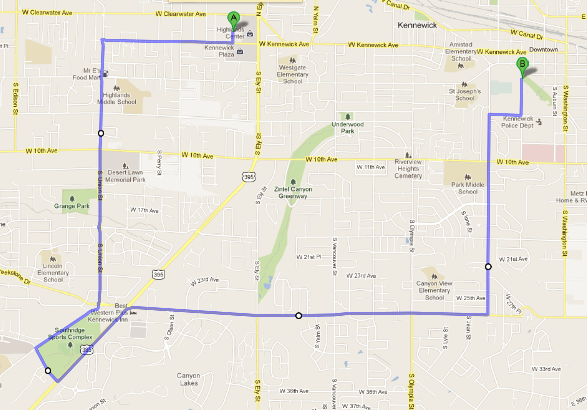
Route 47 with the Southridge deviation
As requested by the Kennewick Parks & Recreation department, Route 47 will be making a deviation south to the Southridge area. Currently, Route 47 stays on 27th Avenue east of Union Street. With the deviation, this will be changed so that the bus continues south from the 27th/Creekstone/Union/Southridge roundabout onto Southridge Blvd. From Southridge Blvd, the bus will head east on Hildebrand Blvd, and then north on Highway 395 before heading east onto 27th Avenue and continuing with the existing route. With this route change, there will be 3 stops that will have service temporarily discontinued. 2 of them are located approximately at 4300 West 27th Avenue (in between Union Street and Highway 395). The third is located on 28th Avenue, just east of Wal-Mart, and is only served by the eastbound 47 currently on a “loop-back.” The discontinuation of this stop is likely to ruffle a few feathers, as I’ve already heard several passengers complain about this. On a personal level, I think it’s a stop that should have never been put in place, but I can certainly sympathize with those impacted. However, noting that there is a stop already at 27th Avenue and Quillan Street (next to Burger King), I don’t think it’s a big impact.
Transit Journal
Posted: May 6, 2013 Filed under: Transit Leave a commentOver the course of the last month, I embarked on a challenge to keep my own personal “Transit Journal.”
In this “Transit Journal,” I kept record of a multitude of things. The primary focus of this was to keep a record of my bus rides so I could determine the exact value of what my transit pass was actually worth to me personally. Along with tracking my origin/destination points, I also kept track of:
- Routes
- Buses
- Fare Value
Since Ben Franklin Transit doesn’t operate transit service on Sundays here in the Tri-Cities, I was left with 26 days over the course of the 30-day month to keep track of all this data. After going over all the data I compiled, a lot of the results came as no shock, but there were a few surprises in it.
September 2013 Service Revision Proposal
Posted: March 25, 2013 Filed under: Transit Leave a commentIn order to keep the network operating at an efficient level, officials at Spokane Transit have several different route and schedule changes they propose to make in September this year, when the Fall “Mark-Up” begins. For the most part, the major changes are focused on routes serving Spokane Valley. Below is a route by route list of the changes that are proposed.
Transit Tourism – Pittsburgh
Posted: February 28, 2013 Filed under: Epic Transit Journey, Fun, Transit, Transit Tourism 2 Comments(Back in March 2012, I took a trip to Pittsburgh for a weekend getaway. While I was there I got to check out the local transit system, Port Authority of Allegheny County, as well as meet some fellow transit nerds. Though the trip to Pittsburgh itself was quite eventful, I’m going to begin this story after I found my bag at baggage claim. Fair warning, this is a long post.)

Route 28X at Pittsburgh International Airport
With my bag in hand, I was ready to leave the airport and get to my hotel for the night. While I was walking through Door 6 and headed towards the stop for Route 28X, I saw a bunch of people standing by the bus like they were waiting for something. As I got closer to the bus, I saw the driver close the door and pull away. A bit confused at that point, I wasn’t sure what had just happened. I overheard another passenger telling someone else that the driver was just pulling around. Looking at the schedule posted on the stop flag, this added up, so I figured I didn’t have much to worry about. A few minutes later, the bus pulled in to the stop again, and everyone started to board.

“VARE-point” farebox
Before I’d even got to Pittsburgh, I’d taken a crash course on PAT’s fare structure. (Note that Port Authority of Allegheny County is often referred to as “PAT,” and that’s the name I’ll be using throughout this post.) Since I was at the airport, located in the far western edge of Allegheny County, I had to pay a 2-Zone fare of $3.25. With about $5 worth of quarters weighing me down, I figured it would be a good idea to pay my fare with them. I soon found myself regretting that decision when I stepped on to the bus and came face to face with the “VARE-point” farebox. A recent acquisition by PAT as part of the transition to the ConnectCard system (more on that later), the farebox is built by a German company called Scheidt & Bachmann. Before 2002, S&B had never built a farebox that could be used on buses and LRV’s. That changed when they won a contract with Boston’s MBTA to build their new fareboxes. A lot of the design was based on specifications S&B got from MBTA, and was later tweaked after several weeks of testing. Perhaps the most noticeable feature (or mistake, depending on who you ask) of the design is the bill/coin collector. Reminiscent of something you would see on a vending machine, the coin collector requires one to feed in coins individually, slowing down the already slow process of cash payments immensely. As I stood on that bus feeding 13 quarters in one by one, I could tell the driver was getting impatient fast, and the grumbles from behind me told me that the other passengers were doing the same. By my count, it took about 20 seconds from the moment I first stepped up to the farebox to the moment my last quarter was accepted by the farebox. On an individual basis, this may not seem like a big deal, but those 20 seconds add up fast when there is more than one passenger paying with cash at the same stop. At the airport stop, there were about 15 people boarding, with about 6 or 7 paying in cash. For this reason and many more, it became obvious fast that PAT needed to find a way to get passengers away from paying by cash.
Dayton Street Transit Center
Posted: January 23, 2013 Filed under: Transit 2 CommentsWhen Ben Franklin Transit first started operations in 1982, they had no transit centers. Instead, buses connected at a designated street block/intersection or private parking lot. In Pasco, buses stopped on 4th Ave between Lewis St and Columbia St, next to the modern location of the Pasco Farmer’s Market. In Richland, the transfer point was at the corner of Knight St and Jadwin Ave, next to the Federal Building. (If you go there today, you can still see where the bus pullouts were.) In West Richland, buses stopped on Van Giesen St, next to West Richland City Hall. In Kennewick, there were 3 different transfer points. On the west end of the city, there was a transfer point in the parking lot of Columbia Center Mall (first on the east end, later moved to the west end where it remained until Three Rivers TC was built.) In the central part of the city, buses connected on Morain St just north of Clearwater Ave near the site of the old Sanders Field until Huntington TC, BFT’s first transit center, was opened in 1986. Lastly, there is east Kennewick, and that’s what I’m going to be focusing on in this post.

Dayton Street Transfer Point (July 2011)
In the beginning, east Kennewick had a transfer point at the corner of 6th Ave and Auburn St, next to the Benton PUD building (more recently the location of the Kennewick School District offices, and now vacant). Sometime in the mid-1980’s, a curbside transfer point was built on the 900-block of South Dayton St next to Columbia Industries. Apart from a widened sidewalk and some concrete benches, it was a very minimalist facility. (It does still get used on occasion presently when the Cavalcade of Bands or the Benton Franklin Fair Parade closes streets in the downtown area.) Some years later, the transfer point was moved yet again to the current location on the 200-block of South Dayton St next to Keewaydin Park. Like the previous transfer point at Columbia Industries, the sidewalk was widened to accommodate the extra foot traffic. A rest station (operator bathrooms and maintenance closet) was also constructed, and a couple of shelters and some lights were added in. This is where the modern Dayton Street Transit Center (officially referred to by BFT as Dayton Transfer Point) remains today. Before the dip in sales tax revenue started to affect BFT’s budget, as many as 9 buses would stage at Dayton Street TC at once. Today, up to 6 buses can be seen making connections (Routes 41, 42, 47, 48, 160EB, and 160WB).
Epic Transit Journey – Coeur d’Alene
Posted: January 18, 2013 Filed under: Epic Transit Journey, Fun, Transit, Transit Tourism Leave a comment
Sherman Avenue in Downtown Coeur d’Alene
Ever since I moved back to the Pacific Northwest in July last year, I’ve been itching to start taking some Epic Transit Journeys again. Earlier this month on Sunday, January 6th, I finally decided to go on one. Located about 30 miles east of Spokane lies the city of Coeur d’Alene, Idaho. The city is more well known as a summer resort town, as it lies right on the shores of majestic Lake Coeur d’Alene, but it is also popular with winter tourists who come to visit one of the ski resorts in the area. While I like to ski, I had other reasons to visit Coeur d’Alene, or CDA as many locals refer to it as. First and foremost, I wanted to check out the local transit system, called Citylink. I also planned to check out the downtown CDA and see the sights there, along with enjoying the tastes at a highly popular eatery in town. Anything else that I happened to find would just be a fun surprise. I was also a bit excited about the fact that my transportation costs would be costing me absolutely nothing, a first for the Epic Transit Journey series.
To get to CDA, there aren’t many non-car alternatives. Though both Spokane and CDA have their own transit systems, there is no public transportation route linking the two cities. However, it should be noted that the MPO’s in both metros recognize the lack of that link as a major need to address. There is intercity bus service operated by Greyhound and Northwestern Trailways that connect the two cities. However, with the starting ticket price being about $14.50 one-way, this is a highly impractical option that very few, if any, would want to rely on. There is only one option to bridge the gap between the two cities, and that option is a another first for the Epic Transit Journey series: A casino shuttle. About 25 miles south of CDA on the tribal lands of the Coeur d’Alene Tribe is the Coeur d’Alene Casino. Open since 1993, the casino is a popular destination for many in the region, a large number of whom come from the Spokane area. Recognizing this, the casino operates two shuttle routes which provide a free ride from Spokane or Spokane Valley direct to the casino. I’m sure the thinking behind it is that if they can get their customers to save money on gas, they’ll spend more at the casino. As you have to be 18 or older to gamble, the shuttle service is also restricted to those of gambling age.
Tampa Bay Light Rail (Part 1)
Posted: December 31, 2012 Filed under: Transit 4 Comments It’s been a hot button topic in Tampa Bay for many years: Light Rail – to build or not to build?
As early as the 1970’s, it’s been talked about over and over in the area. Advocates say that it’s years overdue, will better the economy of the area, and is a much more practical solution than continually building and expanding roads. Opponents say that the small number of transit passengers in the area doesn’t warrant the costly expenditures and maintenance and are vehemently opposed to any increase in taxes to pay for the system.
This is a pro-transit blog, and as such, I am on the side of the advocates. Having spent several months living in Tampa earlier this year, I got a first-hand look at just how badly the Tampa Bay area needs light rail. Transit ridership has been continually growing month after month (so many months in a row that I’ve lost track) on HART, and PSTA has been setting their own record ridership numbers. Keeping in mind that these ridership increases have happened in the midst of service cuts, fare hikes, and the recession, it’s fairly obvious that transit is proving itself.
Snow Detour
Posted: November 13, 2012 Filed under: Transit Leave a comment Over the course of the last few days, the Spokane area saw the first real snowfall of the season. So I figured now would be a good time to talk about an important snow-related topic: The Snow Detour. The fact of the matter is that the Spokane area gets snow. There’s no avoiding that. Sometimes, that snow accumulates enough to start making roads impassable. For people that ride transit, particularly those who are absolutely dependant on it, this can have serious implications.
The good news is that Spokane Transit has designated snow detours for 17 routes (more than half the routes in the system). On each route with a snow detour, the route map has the following info:
Pre-planned Snow Detours: Many bus route have sements that become blocked during snow-ice storms. Hills and narrow streets are the most common problem areas. Pre-planned detours (such as the one shown on this map) have been created so customers can plan accordingly. Detours will only be in effect as needed and for the minimum time possible. The STA wesbsite will always have the most up-to-date information on snow detours. You can also sign up for detour notices via Facebook, Twitter, RSS feeds, or SMS text messaging at www.spokanetransit.com.
 On that same route map/schedule, the specific snow detour(s) for each route are shown, with a short explanation of what street(s) the bus will drive on during the snow detour, and in select cases a more detailed explanation of what street(s) will not be served during the detour. A special notation is also seen on the maps for Routes 60 and 61, which bypass the Browne’s Addition neighborhood during snow detours, but retain service through a snow shuttle.
As noted earlier, snow detours only stay in effect for as long as needed. STA and the City of Spokane have worked together to make sure that the roads travelled by STA buses are on the priority list of roads that need clearing. From what I’ve been told by operators and riders, this plan usually works out okay, but it’s not always guaranteed. During a record-setting 17 inches of snow in 24hrs back in 2008, nearly all bus service was brought to a halt, but so was the rest of the region.


